How North Korea's nuclear blast made a mountain collapse
A look at how scientists used sophisticated technology to compile detailed radar data to show the devastating impact of North Korea’s largest underground nuclear test.
Using sophisticated technology, scientists have compiled detailed radar data to show the devastating impact of North Korea’s largest underground nuclear test.
The test took place beneath Mt. Mantap in the northern part of the country on Sept. 3, 2017, causing the mountain to collapse. Such was the force of the blast that the surrounding area was rocked like a 5.2-magnitude earthquake, according to the international team of experts.
The underground nuclear blast pushed the surface of Mt. Mantap outward by as much as 11 feet and left the mountain about 20 inches shorter, they said. Experts based their analysis on regional and global seismic recordings, as well as before-and-after radar measurements of the mountain’s surface by Germany's TerraSAR-X and Japan's ALOS-2 radar imaging satellites.
Why did North Korea announce closure of nuclear test site?
Did Kim Jong Un make decision as an act of good faith or was his hand forced by a collapse of North Korea's nuclear test mountain? Analysis from Gen. Jack Keane, Fox News senior strategic analyst.
The analysis was released this this week in advance of publication in the journal Science.
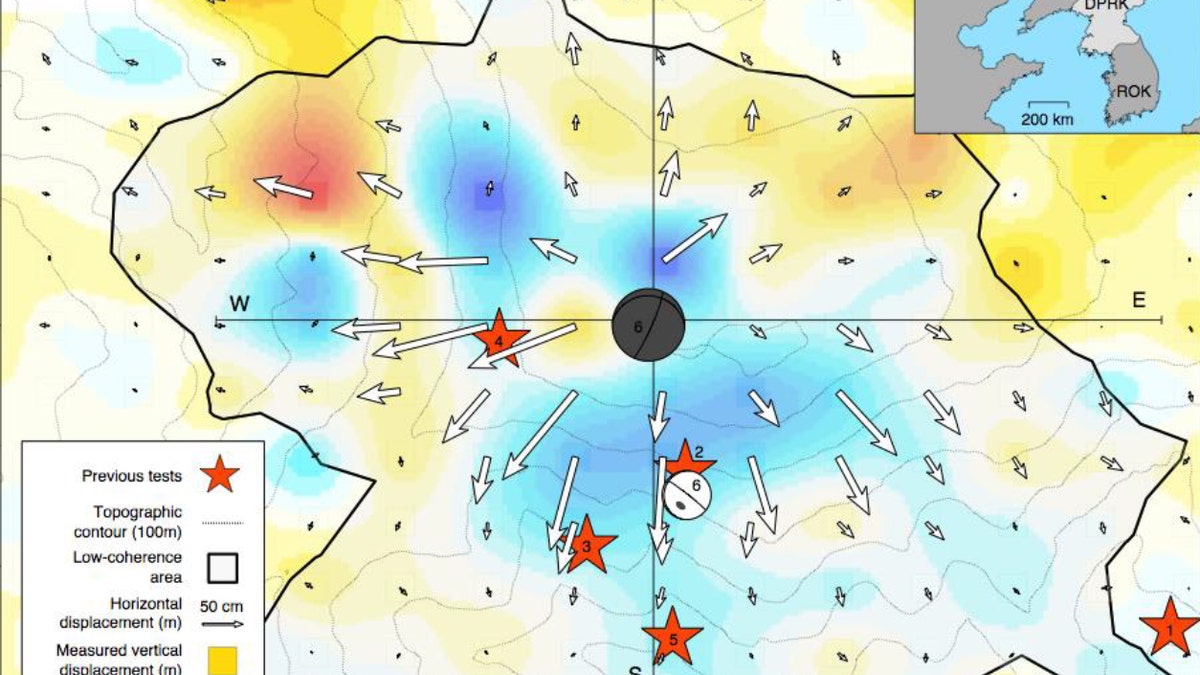
Ground movement on Mt. Mantap caused by North Korea’s Sept. 3 underground nuclear test. Arrows indicate horizontal displacement; color indicates vertical motion. The explosion caused substantial surface disturbance and large displacements over an area of about 3.5 square miles (black outline). Red stars indicate the locations of previous nuclear bomb tests. Balls are locations and magnitudes of the explosion (black, Mw 5.24) and aftershock (white, Mw 4.5). (Credit: Earth Observatory of Singapore, Nanyang Technological University)
Scientists from the University of California, Berkeley, the German Research Centre for Geosciences in Potsdam, Leibniz Universität Hannover, Singapore’s Nanyang Technological University and the Chinese Academy of Sciences in Beijing participated in the research. The project was also supported by the U.S. Air Force Research Laboratory.
Using computer modelling, the team was able to pinpoint the precise location of the explosion, which was directly beneath the mountain’s mile-high summit. They were also able to identify the depth of the blast, which occurred between a quarter and a third of a mile below the peak.
CHINA BUILDING SYSTEM TO DETECT EARTHQUAKES 3 WEEKS IN ADVANCE
Experts also located the site of an aftershock that occurred 8.5 minutes after the nuclear explosion and about 2,300 feet south of the bomb blast. The second seismic event, they speculate, may have been caused by a collapsing tunnel or a cavity left over from a previous nuclear test.
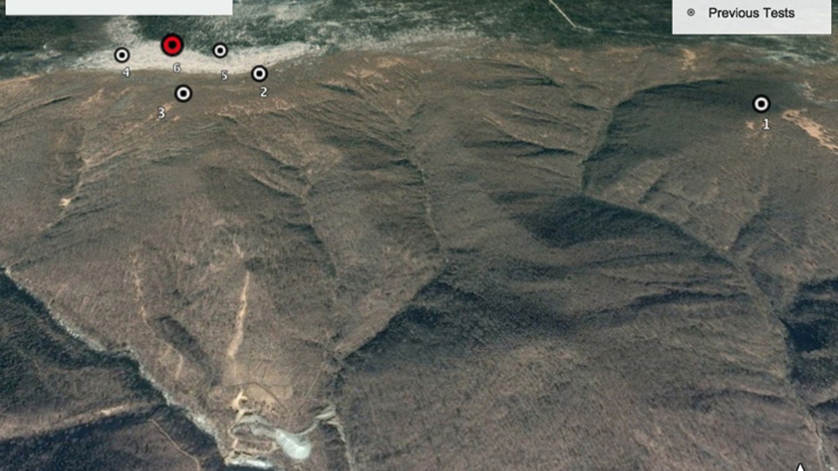
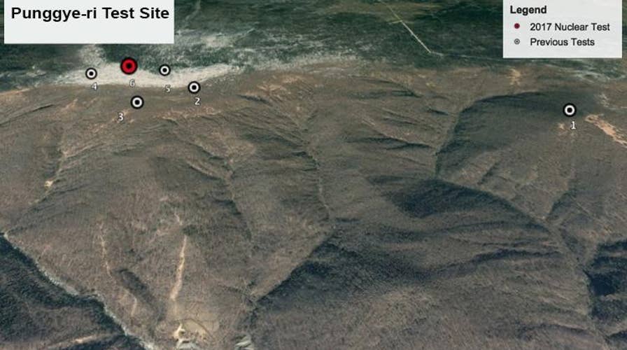
Google Earth image of Mt. Mantap in North Korea's Punggye-ri nuclear test site showing the locations of the nation’s six nuclear bomb tests, including the Sept. 3, 2017, test (red), the largest, which lowered the mountain by 20 inches. (Courtesy of Google Earth)
The Mt. Mantap explosion was the rogue state’s sixth-ever nuclear test and rumors of its impact on the ‘stressed’ mountain made headlines around the globe.
The latest high-tech radar data offer a fascinating glimpse into North Korea’s shadowy nuclear program, which has long been the source of international concern. "This is the first time the complete three-dimensional surface displacements associated with an underground nuclear test were imaged and presented to the public," said lead author Teng Wang of the Earth Observatory of Singapore at Nanyang Technological University, in a statement.
TREASURE ISLAND: RARE METALS DISCOVERY ON REMOTE PACIFIC ATOLL IS WORTH BILLIONS OF DOLLARS
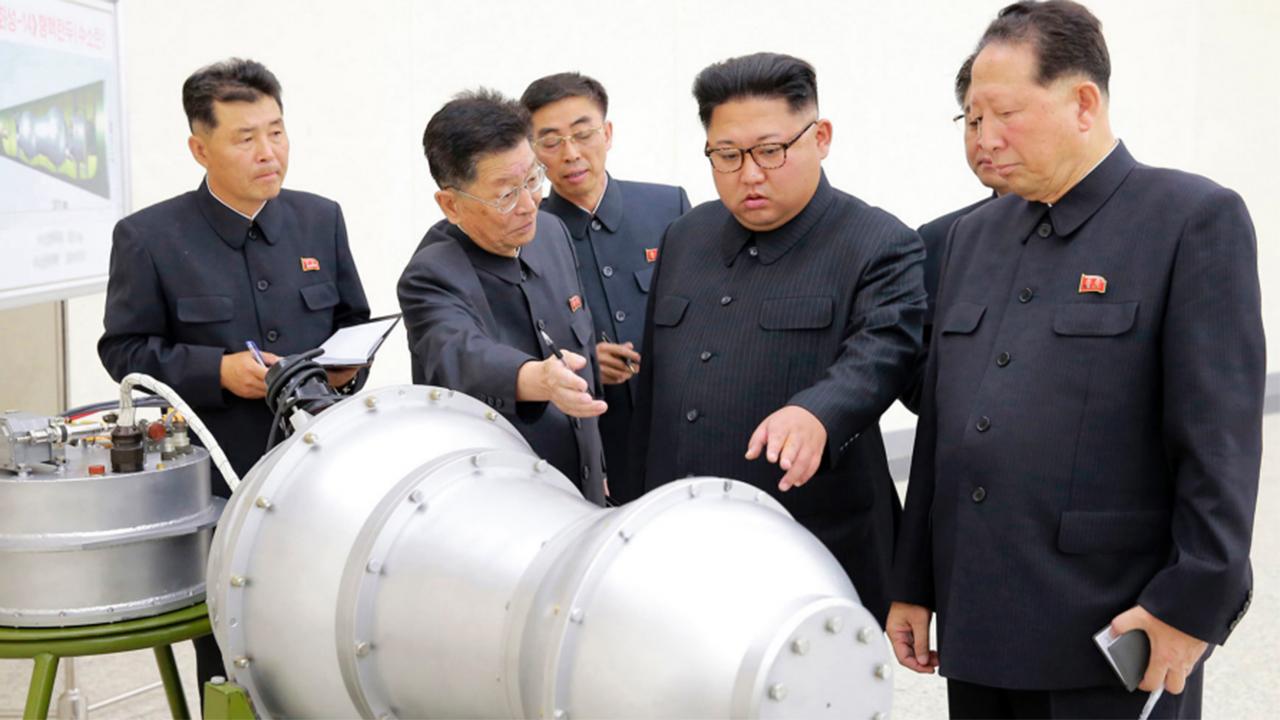
The fifth and sixth tests within Mt. Mantap had a yield between 120 and 300 kilotons, about 10 times the strength of the bomb dropped by the U.S. on Hiroshima during World War II, according to the scientists involved in the study. “That makes it either a small hydrogen, or fusion, bomb or a large atomic, or fission, bomb,” they explained, in a statement.

File Photo - North Korean leader Kim Jong Un attends a military drill between Korean People's Army (KPA) Large Combined Unit 526 and KPA Combined Unit 478 at an undisclosed location in this undated photo released by North Korea's Korean Central News Agency (KCNA) (REUTERS/KCNA)
The use of satellite radar imaging, called SAR (synthetic aperture radar), was a key part of the research, enabling the team to create a completely new picture of the how the explosion changed the mountain.
“SAR really has a unique role to play in monitoring explosions because it is direct imaging of the local ground surface, unlike seismology, where you learn the nature of the source analyzing waves radiating outward from the event at distant stations,” said Douglas Dreger, a UC Berkeley professor of earth and planetary science and a member of the Berkeley Seismological Laboratory, in a statement. “This is the first time anyone has actually modeled the mechanics of an underground explosion using satellite and seismic data together.”
METEORITE HUNTERS: SCIENTISTS SET TO SCOUR ANTARCTICA FOR RARE SPACE ROCKS
Mt. Mantap is part of North Korea’s Punggye-ri nuclear test site. There has been speculation that the mountain’s collapse may have prompted North Korea’s recent decision to suspend its nuclear and missile testing.
There are, however, conflicting theories about the precise location of the sixth North Korean nuclear test. A separate scientific study, for example, placed the blast nearly a kilometer (0.6 miles) northwest of the site identified in the latest research.
U.S. President Donald Trump announced in a tweet Thursday that he will meet North Korean leader Kim Jong Un in Singapore on June 12.
Fox News’ Katherine Lam and the Associated Press contributed to this report.
Follow James Rogers on Twitter @jamesjrogers

Get a daily look at what’s developing in science and technology throughout the world.