Severe Thunderstorm Watches stretch over 1,000 miles from Plains into Tennessee Valley
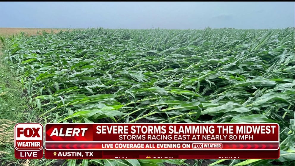
A derecho event on Thursday caused widespread wind damage reports across more than 500 miles from Omaha, Nebraska, to the Ohio River.
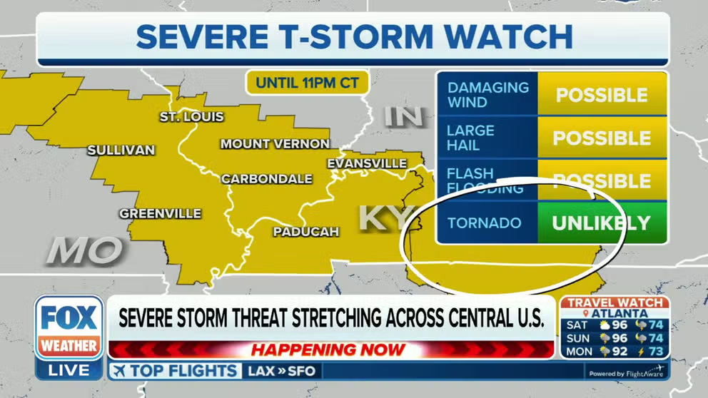
Severe Thunderstorm Watch issued in Midwest
A Severe Thunderstorm Watch has been issued Friday for parts of the Midwest that were hit hard by Thursday's derecho.
The FOX Forecast Center is monitoring the risk for storms on Friday that could travel over some of the same communities impacted by a derecho event just 24 hours before.
Strong to severe storms are expected to develop over the Plains and work eastward through the morning and afternoon.
NOAA's Storm Prediction Center has issued several Severe Thunderstorm Watches from the Plains through central Tennessee due to the threat of large hail and wind gusts to 75 mph.
A Severe Thunderstorm Watch means conditions are favorable for the development of damaging thunderstorms in and close to the alerted region.
The watches include Kansas City, St. Louis and part of the Nashville metro.
DERECHO WITH 100-MPH WINDS RIPS ACROSS MIDWEST LEAVING BEHIND WIDESPREAD DAMAGE

(FOX Weather)
The FOX Forecast Center said plenty of moisture will be in place as well as instability that will help support another long-duration storm event.
The SPC has highlighted communities in more than a dozen states for seeing an increased risk from severe storms that includes hail and damaging winds.
Included in the likely zone for severe storms are Lincoln, Nebraska; St. Louis, Missouri; Louisville, Kentucky; and Nashville.
(FOX Weather)
The pattern is very similar to the past couple of days, with a ridge parked over the central U.S., forcing storms to move along its northern periphery. This phenomenon is frequently referred to as the "ring of fire."
"And we have to watch out for some isolated minor instances of flash flooding because you obviously got a lot of rain on Thursday, and more rain is just going to increase that risk for flash flooding," said FOX Weather meteorologist Kelly Costa.
Recovery underway from 500-mile derecho event
Utility crews continue to try to restore power to more than 500,000 businesses and homes that were left in the dark after Thursday’s round of severe storms.
The FOX Forecast Center said the event was a derecho that traveled more than 500 miles from eastern Nebraska through the Ohio Valley.
Along the route, the SPC received hundreds of wind reports, and in some communities, gusts were estimated to have reached 90 to 100 mph.
The damaging winds knocked over trees, power lines and flattened crops.
Crop damage reported in Midwest following Thursday's derecho
A line of severe storms with damaging wind gusts and embedded tornadoes moved through Illinois and Indiana on Thursday. Meteorologist Andrew Pritchard said the damage did not to be as extensive as the August 2020 derecho.
There were no initial reports of fatalities connected to the event, but several people were reported to be injured due to falling trees.
Tracking a derecho during the summer is not an uncommon event. The National Weather Service estimates 70% of all derechos occur between May and August.
Many weather watchers compared Thursday’s event to a historic derecho that moved through the Midwest in 2020, which caused an estimated $11 billion in damage.
"The damage is widespread, but at the same time, it’s not quite as bad as we saw in 2020," said Andrew Pritchard, a local meteorologist based in Illinois. "And I think that the bigger thing here is we just needed to finally get this pattern to break, to start letting some of these summer thunderstorm complexes to come in, because that is the nature of thunderstorms we get in the summertime in the Midwest. We need them because they bring the rain that we need during the summer."

A shelf cloud moves through Charleston, Illinois, on Thursday.
(FOX Weather)