MIT researchers say that an autonomous drone fleet could help find lost hikers. (Melanie Gonick)
Researchers at MIT say that a sophisticated fleet of drones could help find lost hikers by searching under dense forest canopies.
The autonomous drones would bypass the problem of unreliable or nonexistent GPS signals in forest environments by using onboard computation and wireless communication, according to the experts.
The team’s research is revealed in a paper that will be presented at the International Symposium on Experimental Robotics conference in Buenos Aires, Argentina, this week.
DRONE SAVES AUSTRALIAN TEEN SWIMMERS IN WORLD'S 1ST RESCUE MISSION WITH UNMANNED AIRCRAFT
Using laser range-finders to estimate their position and plan a route, the drones will create 3-D maps of the terrain. Algorithms will be employed to help the drones identify unexplored areas and places that it has already searched.
Eventually, researchers want to give the drones object detection technology to help identify missing hikers. This would tag the hiker’s location on a map that can be used by human rescuers.
“Essentially, we’re replacing humans with a fleet of drones to make the search part of the search-and-rescue process more efficient,” said the paper’s lead author Yulun Tian, a graduate student in the Department of Aeronautics and Astronautics (AeroAstro).
'LOST CITY' REVEALED IN SOUTH AFRICA USING LASER TECHNOLOGY
The MIT experts tested a number of drones in forest simulations, and also tested two drones in a forested area at NASA’s Langley Research Center in Virginia. “In both experiments, each drone mapped a roughly 20-square-meter area in about two to five minutes and collaboratively fused their maps together in real-time,” they said, in a statement. “The drones also performed well across several metrics, including overall speed and time to complete the mission, detection of forest features, and accurate merging of maps.”
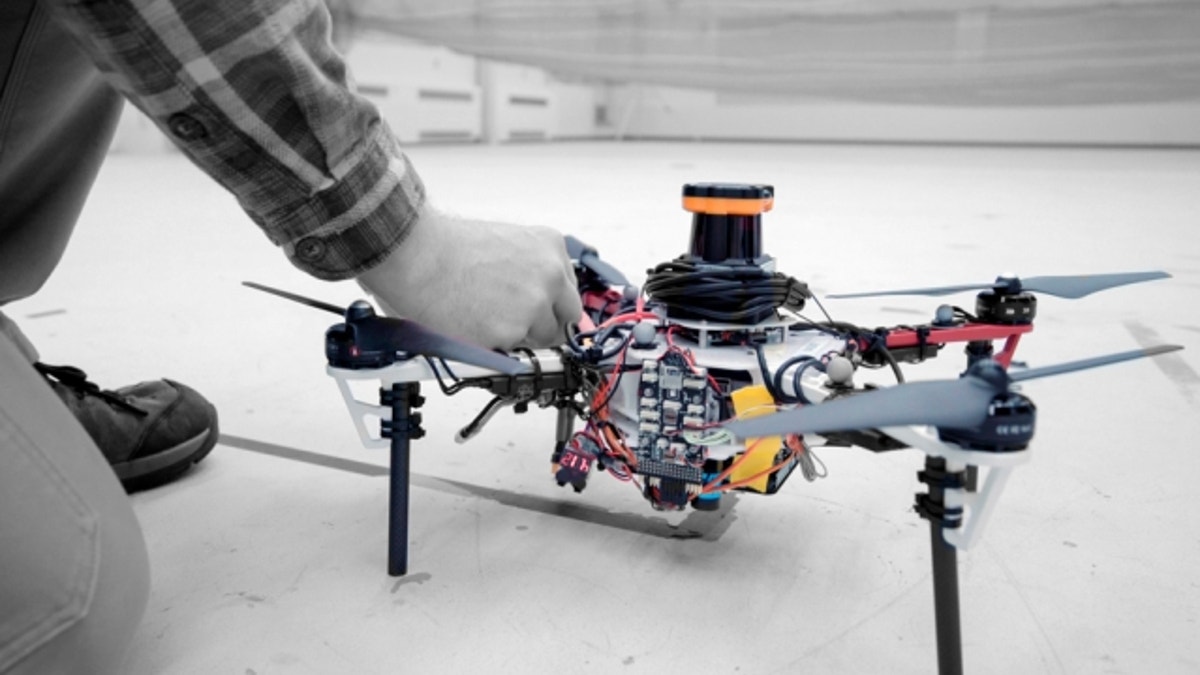
A LiDAR (Light Detection and Ranging) system was mounted on the drones to create a 2-D scan of surrounding obstacles. LiDAR uses a laser to measure distances to the Earth’s surface and can prove extremely valuable to study areas with thick vegetation. The technology, for example, has been used to locate a number of archaeological sites.
Archaeologists, for example, have harnessed the technology to reveal lost cities and thousands of ancient structures deep in the Guatemalan jungle.
MYSTERIOUS LOST MAYA CITIES DISCOVERED IN GUATEMALAN JUNGLE
LiDAR is also used extensively in other applications, including autonomous cars, where it allows vehicles to have a continuous 360 degrees view.
The MIT team programmed the drones to identify the orientations of multiple trees – an algorithm was used to calculate the angles and distances between trees to pinpoint specific clusters. “Drones can use that as a unique signature to tell if they’ve visited this area before or if it’s a new area,” said Tian.
The drones communicate with a ground station that uses specialized navigation software to map unknown areas and keep track of the flying robots. The Simultaneous Localization and Mapping (SLAM) software uses the LiDAR data to capture the drones’ positions and accurately fuse the digital maps they create.
AERIAL LASER DISCOVERS ANCIENT ROMAN GOLD MINES
However, researchers would like to reduce the drones’ reliance on the ground station. The team hopes to design the drones to communicate wirelessly when approaching one another, fusing their maps, and cutting communication when they separate. “The ground station, in that case, would only be used to monitor the updated global map,” they explain, in the statement.
Rescue services are increasingly harnessing drone technology. Earlier this year, lifeguards in Australia used a drone to help save two teenage boys caught in dangerous waves in what was described as the world’s first rescue by unmanned aircraft.
Fox News’ Katherine Lam contributed to this article.
Follow James Rogers on Twitter @jamesjrogers

Get a daily look at what’s developing in science and technology throughout the world.